Saturday, April 22, 2006

CREEKSIDE TRAIL


Joel McKenney and Al Geene are pictured on a November 2004 Trail-Day outing to install new signs on our popular Five Forks Trail. This short trail begins north of the picnic area and ends on Beacon Hill Drive. Many feel the best route to walk is clockwise, walking down Five Forks Drive and up the trail. Plans are currently underway to install a bench near the bridge so trail users can rest and enjoy the wilderness area along the un-named creek.


Wednesday, April 12, 2006

Turtletown Falls, Tennessee


On Tuesday, April 11, 2006 seven members of the Five Forks Hiking Club drove 28 miles north west into the Cherokee National Forest in Tennessee for a walk along the Turtletown Creek to two beautiful waterfalls. Joining us for their first outing were Sandy and Mickey Bradley, daughter Misty and her friend Tony, pictured here at the Upper Falls.


These falls are reached after a one mile walk from the parking area.


Here is another view of the Upper Falls. Another three quarters of a mile along a quiet woods trail brought us to the Lower Falls.


After time spent taking pictures we returned via the same trail, much of it along side the tumbling Turtletown Creek.


Saturday, April 08, 2006

SOUTHERN TERMINUS of APPALACHIAN TRAIL


On Friday April 7, 2006, Jon and Clyde drove through Blue Ridge , GA and down Aska Road to Forest Service Road 42 where they parked at its junction with the Appalachian Trail.

Hiking south on the AT, in 0.9 mile they arrived at the southern terminus of this 2000 mile plus trail that ends its journy at Mount Katahdin, ME. Approximatley 2500 end to end hikers attempt this trek every year, beginning in Feb, Mar and April. The highlight of this hike and Wednesday's hike over Blood Mountain, was the opportunity to meet and talk with many of the thru hikers.

The Georgia AT club even has a caretaker stationed near the summit to educate hikers about the trail and how to maintain it while hiking. 
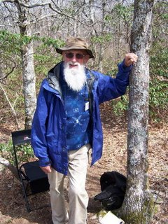
"Many Sleeps" turned out to be quite a character with lots of tales to share with everyone. We easily spent over an hour at the summit and near by Springer Mountain shelter meeting several thru hikers and many just out for the day, having hiked up the 8.3 mile trail from Amicalola Falls State Park.
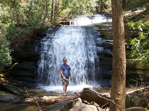
After walking back to our vehicle we continued our outing by driving to the trailhead to Long Creek Falls, along side the AT.


LONG CREEK FALLS


Long Creek Falls is located on a 0.1 mile blue blazed side trail off the Appalachian Trail, about one mile north of "Three Forks", the junction of three streams that join together to form the Noontootla River, on Forest Service Road 58. By AT miles, Long Creek Falls is 5 miles north of its southern terminus. note: on todays hike, April 7, 2006, FS 58 was closed near its southern end because of a cave in of the road.

Jon and Clyde drove to the Three Forks parking area after their hike to the Springer Mountain summit and hiked the easy, former jeep road (uphill) to the junction with the trail to the falls and also where the Benton MacKaye and Duncan Ridge Trails seperate from the Appalachian Trail. Out and back from FS 58 is a total of 2.2 miles.

Friday, April 07, 2006

LOOP HIKE ON BLOOD MOUNTAIN, GA


On April 5, 2006 members of the Five Forks Walking Club took a 5.5 mile loop hike to the 4461' summit of Blood Mountain, the highest elevation on the Appalachian Trail in Georgia. Traveling south on US 19/129 through Blairsville to a parking area just north of Neel's Gap, we took the connector trail 0.7 mile to junction with AT and then hiked west on AT 1.4 miles to summit with its historic trail shelter built by the CCC in the 30's. From the summit we again walked west on AT for another 0.8 miles to junction with the 1.8 mile Freeman Trail.


We hiked east on the Freeman Trail, below the summit of Blood Mountain on a rocky path, reaching the junction of the AT and the Connector Trail, then back to parking area for a total of 5.5 miles.

It took us 5 hours plus to travel this distance because we met at least 50 others on the trail, many of them THRU-HIKERS just beginning their journy to Maine. It seemed we had a long conversation with each group we met!

Blood Mountain is only 28 miles from the southern terminus of the Appalachian Trail.


Thursday, April 06, 2006

HEMLOCK FALLS HIKE


On Wednesday March 29, 2006, Jon Opsahl and Clyde Godschall traveled east on GA 76, through Hiawassee to GA route 197, then south to the Moccasin Creek State Park. Parking on the west side of 197, they hiked one mile to the lower falls on Moccasin Creek, named Hemlock Falls.

It was a perfect day for both walking and picture taking. After wading across the creek above the falls, they continued up stream another three-quarters of a mile to the upper falls, just as spectacular to view.

The trail above Hemlock Falls is very rough walking because of numerous downed trees from a recent hurricane. Above the upper falls it is an additional 4 miles to the Appalachian Trail at Addis Gap, however it is not recommended you try this difficult trail.

On returning to their vehicle another crossing of Moccasin Creek was made without either walker falling in!


Saturday, April 01, 2006

CHEROKEE LAKE PICNIC AREA


On Friday, March 31, 2006, Jon and Clyde explored the Cherokee Lake Picnic Area, 12 miles from Five Forks on NC 294. This is a small area used mainly for fishing and picnicing.

From the parking area, where there are restrooms and picnic tables and a fishing pier (see photo), there is a short trail that leads to Persimmons Dam where the waters of Persimmons Creek flow into Hiwassee Lake. Cherokee Lake is a fixed level dam and does not "go dry" like the other TVA lakes around us.


The trail from the parking area is only 0.4 mile, however by crossing the dam, you can follow the road on the west side back to 294 and using the entrance road make your hike a 2 mile loop.

The Picnic Area, part of the Nantahala NF opened "officially" on April 1st. The area is closed during the winter season. One week prior to our walk they had a "controled burn" to clear out underbrush.